
Well - it appears the search for a 3+3 over there may be on hold. I may have found a '90 that may just do the job 60 miles from me in the UK!!
West coast is still more favorable, I like the idea of rambling down the old routes rather than the main highways.
So how far would I travel in 18 days? Allowing 2-3 days at a stop.
If I started in the top end of Cali and went south where are the en-route stops?
Bitzer, do you like road trips? Ill try to provide some beta on where I would go and what I would do if I were visiting California. However, realize that late August/early September is the hottest, driest time of year here. Still, on any given day theres a wide range of temperature from place-to-place. When Fresno (the approximate geographic center of California) is 107° F or hotter, San Francisco is in the high 60s, the Sierra Nevada Mountains above 6,500 feet (1,980 m) are in the mid 80s and Los Angeles is in the low 90s. Bear with me....
Essentially, there are three north-south routes through California. But, be advised, California is Big! Youll only scratch the surface of what California has to offer in two and a half weeks. Your choices are nearly limitless with activities and sights for everyone, although youll not have time to achieve them all!
- The western route down California State Route 1 (SR 1) hugs the coastline. It's very scenic with many quaint seaside towns, eateries, wine tasting, lighthouses, beautiful redwood forests (north of San Francisco and around Santa Cruz), the Mystery Spot near Santa Cruz with its mind boggling, logic defying illusions, the Monterey Bay Aquarium (a worthy stop), historic Spanish missions, Point Lobos State Reserve, Julia Pfeiffer Burns - Big Sur State Park (another worthwhile stop with easy hiking trails and McWay Falls that plunges 80 ft (24 m) onto the beach and surf), Solvang Swedish Village lies further south. Generally, the beaches are short, rugged and rocky on the north coast, gradually giving way to long, sandy beaches further south. SR-1 is a beautiful drive with lots of diversions to tempt your curiosity should you decide to follow it to its southern terminus.
- The center of California is traversed north-to-south by US Highway 99 (US 99) and Interstate 5 (I-5), running down the middle of the Great Central Valley, which is rimmed by mountains and stretches 2/3 the length of the State. Although there are notable points of interest along the way, they are widely spaced making for monotonous windshield time. For example, at 14,162 ft (4,317 m) in elevation, standalone Mount Shasta dominates the skyline of northern California with its striking asymmetric cone that is representative of many ancient Cascade Range volcanoes.

Mount Shasta looking northeast from I-5
Mount Shasta creates its own localized weather due to its steep, uninterrupted 9,800 ft (3,000 m) prominence above its roughly circular base and the surrounding terrain. During otherwise clear days, moist air rapidly rising up the flanks of Mount Shasta condenses, perpetually shrouding the peak's snow covered summit in windswept clouds. It is an awesome sight discernible from 100+ miles away. Nevertheless, during late Summer, navigating the Central Valley via US 99 and I-5 is tedious and hot with m-i-l-e-s of gently rolling countryside before coming within sight of solitary Sutter Butte, the route's next prominent landform to the south to fix one's attention and peak curiosity. Seemingly endless distance must be confronted to arrive at the next point of interest.
- Albeit beautiful and diverse in its habit, the eastern route down California is somewhat circuitous with long stretches of aloneness. The route navigates the southernmost extent of the Cascade Range, which trends northwestward through the western regions of Oregon and Washington States. The Cascade Range is anchored in California by slumbering 10,457 ft (3,187 m) Mount Lassen (aka: Lassen Peak) - one of the world's largest active plug dome volcanoes. Lassen Volcanic National Park encompasses many lakes, cascading creeks, waterfalls...
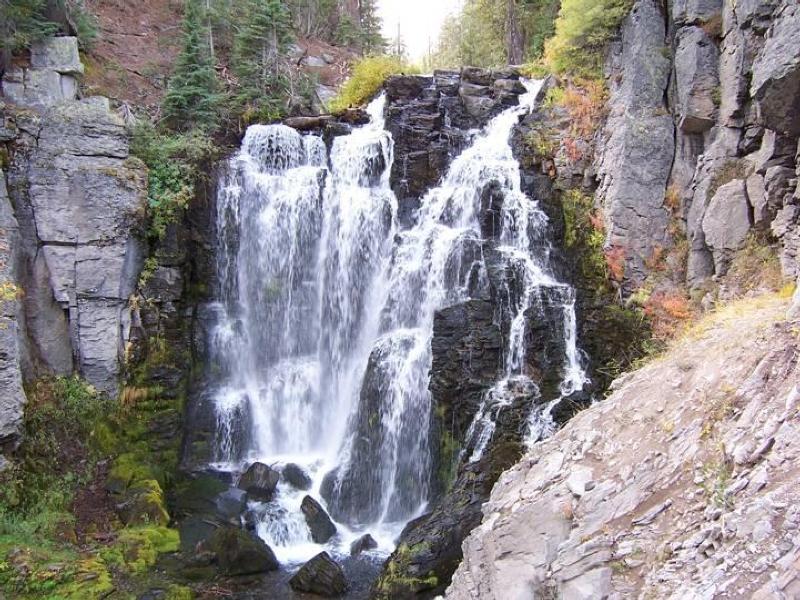
Kings Creek Falls, Lassen Volcanic NP
...and wafting fumaroles. Running south, the highway meanders around many mountain streams and high-desert fringe lakes. Vast views of stark high desert opening toward the east contrast dramatically with the shear granite escarpment and spine of the Sierra Nevada Mountains to the west, towering 4,000+ ft (1,219+ m) above the highway. This contrast in relief becomes more pronounced as you continue south. The eastern route makes for exciting travel, but is best vacationed by someone familiar and comfortable with the random spacing of local services. On the other hand, Summit Racing Equipment is on this route in Sparks, Nevada, northeast of Lake Tahoe and just east of Reno.  Incidentally, Tahoe is a "must see" lake. It is the second deepest in the US at 1,645 ft (500 m) and exhibits ~70 ft (21 m) of near crystal clear visibility.
For a memorable first trip, I recommend that you create your own variation of the following itinerary: Fly into
Klamath Falls, Oregon for the evening. Purchase a detailed road map. Get an early morning start and drive north about 60 miles (97 km) to
Crater Lake NP, a very picturesque, extinct volcano that cradles the deepest lake in the US at ~1,950 ft (595 m)). Then, retracing your route back through Klamath Falls, drive 218 mi (350 km) south past Mount Shasta and Castle Crags State Park to
Redding, California for the night (~4 hrs, plus stops). In the morning, head west on SR-299 toward Arcata, Eureka and the coast (~3 hrs). Follow US 101 south from Eureka to its junction with SR-1 in the tiny settlement of Leggett. Follow winding SR-1 south, taking your time to stop along the way and enjoy the many quaint towns, and occasional diversions to the beach, as it suits you. Continue south over the Golden Gate Bridge into San Francisco. Anticipate one to two days travel time between Eureka and San Francisco, depending on stops (~300 mi, 480 km). Do your best to plan ahead for nightly accommodations. The closer you are to San Francisco, the more lead time youll need to make reservations.
San Francisco offers all the amenities and adventures of any world class, cosmopolitan city. Enjoy a few days roaming around and exploring. Check out
Chinatown, the
Embarcadero, the
Exploratorium,
Fishermans Wharf,
Ghirardelli Square, the
California Academy of Sciences and adjoining
Golden Gate Park. Although pricey, San Francisco offers exquisite dinning, accommodations and entertainment.
Head east across the new
Oakland Bay Bridge then north and east on I-80, switching to US 50 in
Sacramento, then on to
South Lake Tahoe (~4 hrs plus stops). Youre now at an elevation above 6,200 ft (1,890 m). Slather on the ritual sunscreen and enjoy two or three days exploring the scenic and historic Tahoe/Reno/Carson City/
Virginia City area, rich in silver mining lore, Old West history and romance. Take a tour of a silver mine and discover the
Comstock Lode.
Then, pack ample picnic supplies and head south along US 395, to about 3.5 mi (6 km) past the intriguing moonscape of
Mono Lake and Lee Vining, diverting southwest off of 395 for the day, around the
June Lake loop drive. Return to US 395 and turn south to the mountain resort town of
Mammoth, about 30 minutes away, for a restful night's sleep (~5 hrs total driving time, plus stops). By this point youll be 9 - 10 days into your trip.

South shore of Mono Lake looking west toward Mount Dana and the Sierra Crest
Mammoth lies within the western margin of dormant,
Long Valley Caldera - a super volcano that violently erupted and then collapsed about 770,000 years ago, burying a geographic area roughly 850 sq mi (2,200 sq km) to a depth of ~500 ft (170 m) with glowing, superheated ash.... The caldera is approximately 20 mi (32 km) long, east-west, by 11 mi (18 km) wide. Based on its cyclic eruptive history, Long Valley is well overdue for another cataclysmic event! But, rest easy while youre there.
The local office of tourism assures us you are safe...! 
If you feel adventurous, you can take a short drive and walk to the boiling geothermal springs, sulfurous fumaroles and bubbling mudpots spread along
Hot Creek near the central vent of the caldera. But, be very attentive and careful to remain on marked trails, since the ground is in a constant state of change and potentially unstable! Another nearby attraction located along the San Joaquin River just west of Mammoth is
Devils Postpile NM with its impressive, vertical volcanic columns planed off by glaciers during the Ice Age.
Further south and to the east in the White Mountains, which trend sub-parallel to the California-Nevada border, survive some of the oldest living trees in the world, in excess of 5,000 years... the famous and weathered
bristlecone pines. But, these living monuments are too far afield to visit this trip.
In the morning, fuel your vehicle then backtrack about 35 minutes north along US 395 to Lee Vining and Mono Lake. Turn west onto SR-120 toward Yosemite National Park. Climb steadily up this dramatic glacial canyon, rimmed by moraines, cresting out at 9,945 ft (3,031 m) as you cross Tioga Pass, weaving your way past several alpine lakes that punctuate the northern end of Dana Meadows in Yosemite NP. The lofty reddish-brown peak dominating the eastern (left) skyline is 13,053 ft (3,979 m) Mount Dana. The hard won summit of
Mount Dana commands a 360° view that relates the majesty of the Sierra Crest and adjoining ranges - a view that encompasses over 30,000 sq mi (78,000 km
2). The subdued red, brown, yellow, and orange hues of the crest reflect the faulted, folded and baked contact zone between preexisting rocks and the younger, granite core of the mountain range. To a prospector, color alludes to the possibility of enriched mineralization that locally includes silver, gold, copper, tungsten and zinc. As such, many prospects and mines were established along contact zones running the length of the Sierras. It is common for remnants of mining activities to be scattered through and between difficult to access, inhospitable canyons. In fact, two ghost towns haunt this immediate area: Dana and
Bennettville - both, defunct silver mining ventures.
Watch your speed closely as you drive through the Park (forest cops are unforgiving) and be wary of bears when you stop. Dont leave any food or aromatics in your vehicle unattended. Although dominantly nocturnal, Yosemite black bears can appear at anytime of day and peel the doors off of a vehicle as effortlessly as a child peels the wrapper from a candy bar.

Rock climbing in Yosemite NP
Soon after entering the Park the highway swings 90 degrees west into Tuolumne Meadows and follows alongside, then crosses, the proud and clear Tuolumne River. Tuolumne Meadows is a vast, lush, verdant marsh in the Spring, virtually submerged in snow melt with rivulets crisscrossing everywhere one looks. From this vantage, scan the skyline and surrounding high peaks for spectacular views. Study the many granite walls and domes that crowd the highway as you peer for rock climbers. Breathe in inspirational vistas of the High Sierra with its deep sapphire blue lakes.
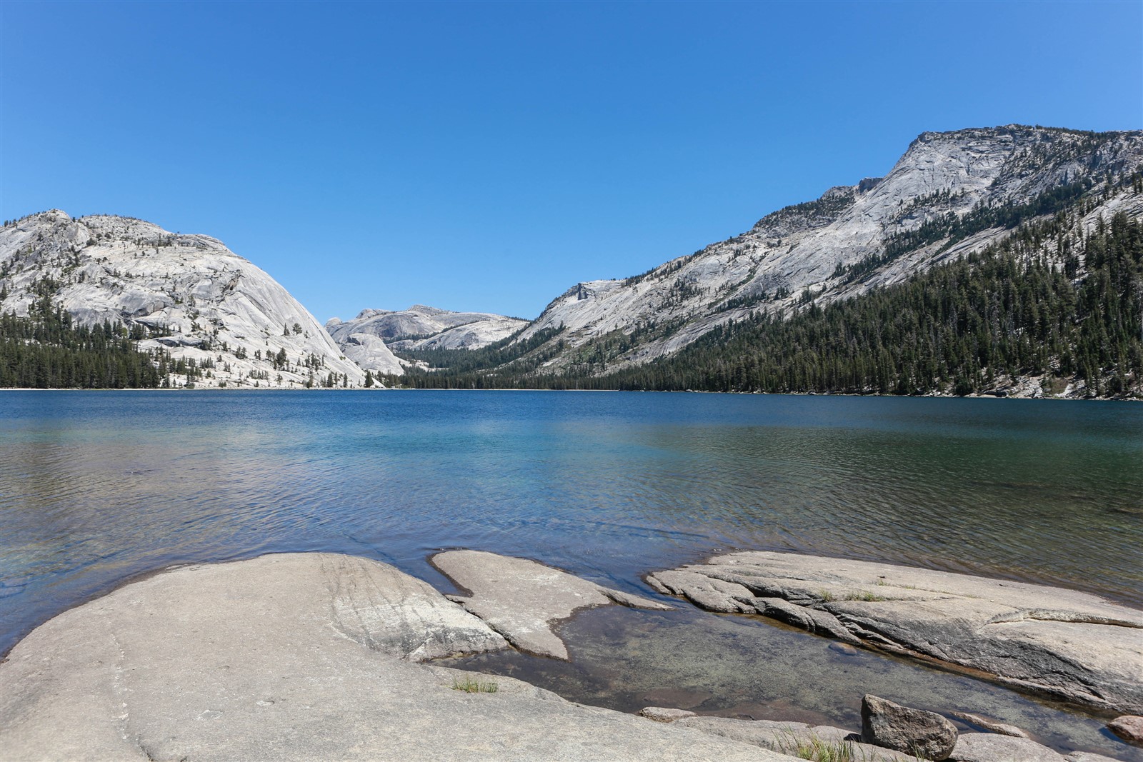
Tenaya Lake looking northeast with Polly Dome at left and Tenaya Peak at right
Continue on SR-120 through the domelands past Tenaya Lake to the
Olmstead Point turnout with its grand view of world famous Half-Dome directly to the south. Explore the sweeping granite surfaces that surround the Point and you are bound to find local examples of shiny glacial polish, vaguely reminiscent of a granite counter top. Continue westward on SR-120 to Crane Flat. Refill with fuel and grab an ice-cream bar and refreshments, then bear left and continue down SR-120 as you descend southeast toward Yosemite Valley. Turn left again when you intersect the El Portal Road (SR-140 from Mariposa). Spend the rest of the day wandering around this world destination park. Exit the Park toward Fresno via SR-41 and spend the night in Oakhurst about 48 mi (77 km), and 1.5 hours away.
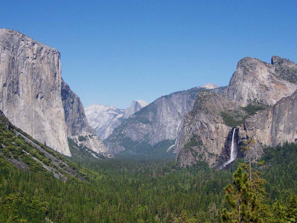
Yosemite Valley looking east with Half-Dome at center farground
After a lazy breakfast, head southwest on SR-41 into Fresno (~45 min). Exit SR-41 at Shaw Avenue and drive west to connect with US 99 northbound. Exit onto SR-152 heading west toward Los Banos.
Remain on SR-152, crossing under I-5 before passing by the San Luis Reservoir on your way toward Gilroy and the Monterey Bay Aquarium. As you approach Gilroy take an hour or so to stop at
Casa de Fruta and enjoy their broad selection of fruits, nuts, candies, and other delectable treats. With any luck, while youre there, peacocks will parade around the park and call out while the train wanders its tracks, blowing its whistle and ringing its bell to your lil one's delight. In addition to savory treats, Casa de Fruta is a decent spot for fuel, a pit stop, and lunch.
Roughly 2 mi (3.2 km) past Casa de Fruta, SR-152 intersects SR-156 and veers north into Gilroy. Continue straight on SR-156. Follow signs to US 101 then turn south toward Monterey. Watch for highway signs to Castroville and Monterey as SR-156 splits west from US 101. Use your map and road signs to find your way to Cannery Row and the Aquarium. Plan on spending several hours looking at the exhibits. Enjoy a sumptuous meal at one of the many fine restaurants on Fisherman's Wharf or Cannery Row (
Bubba Gump is a local favorite). From this point, work your way down or back up the coast at your leisure, using your remaining vacation to enjoy the various parks, towns, beaches and fabulous views. Plan your departure from the US out of San Jose, Los Angeles or any major airport.
I hope this has provided some additional food for thought. Good traveling!


 1
1
